Tap-to-check list
Amanohashidate sandbar: how to cross it and where to swim
List of 6 items
For a day on the sand
Tap items to tick them off. This device remembers your progress.
0 / 6 ready
You are ready. Only the booking is left: your date and your seat on the coach.
Secure your spotA thin strip of sand and pine trees runs across the bay. Here is how long it takes on foot, by bike or by boat, what you pass on the way, and what the official sources say about swimming at the beach.
Editorial team, amanohashidate.top · Updated November 6, 2026 · Allow 6 min
Key facts
- LengthThe sandbar is roughly 3.6 kilometers long, with about 8,000 pine trees growing along it.1
- On foot or bikeThe scenic road through the pines takes about 45 minutes on foot or 15 minutes by bike.2
- By boatThe sightseeing boat between the two ends takes approximately 12 minutes.3
- SwimmingThe beach on the Monju side usually opens for swimming in mid-July.4
- PriceThe day tour that stops here is from $52 per person and gives Amanohashidate 2 hours.
What you are actually walking on
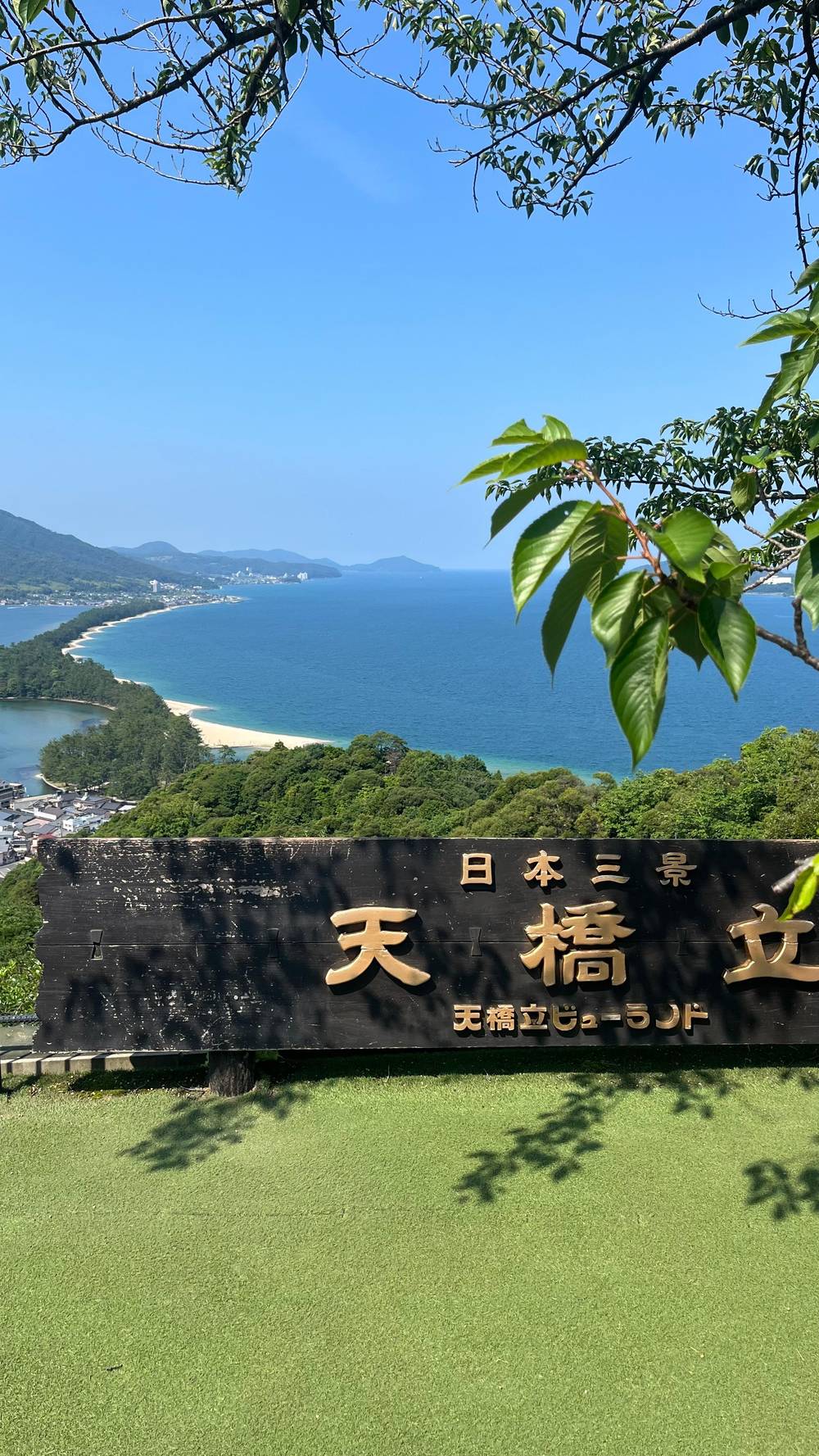
Amanohashidate is a natural land bridge, roughly 3.6 kilometers long, with about 8,000 pine trees growing in the sand along it.1 It separates the Aso Sea from Miyazu Bay.5 At its narrowest point the strip is just 20 meters wide, and most of it is occupied by pine trees.6 That narrowness explains the feel of the walk: sea light flickers through the trunks on both sides.
Japanese tradition counts it among the Three Most Famous Views in Japan, and legend says the deity Izanagi-no-mikoto made it as a path from the heavens.7,8 It also appears on many Best 100 lists, among them 100 Beaches of Japan and 100 Famous Waters.9 For a walker, the path has benches and rest areas along the way.10
You step from the town onto the sand and keep going. The only decision is which direction and how much of it to do. Walking one way and returning by boat or bike is a natural plan, and the sections below give the timings you need to make it.
Ways across
Foot, bike or boat
| Way across | Time | Good to know |
|---|---|---|
| On foot | About 45 minutes2 | Benches and rest areas on the way10 |
| Rental bike | About 15 minutes2 | One-way rentals possible14 |
| Sightseeing boat | Approximately 12 minutes3 | Gulls take snacks from passengers15 |
| Day coach tour | 2 hours at the site | Chairlift and monorail cost extra |
These are travel times, not the time you will spend; allow extra for the bridge, the shrine and photographs.2,3
On foot, by bike or by boat
Japan's national tourism organization gives figures for the road that threads through the trees: about 45 minutes on foot, or 15 minutes by bike, with bikes rented from shops and hotels by Amanohashidate Station.2 The Kyoto prefecture guide puts a rental bicycle crossing at about 15-20 minutes and adds that a one-way rental is possible.14 A one-way rental is the clever choice: ride north, return by boat, and you never retrace your steps. Since the path has benches and rest areas, a walker can stop whenever the legs ask, and a cyclist can hop off to look at the water.10
The boat is the third option. The tourism association says the sightseeing boat linking the southern end, Amanohashidate Sanbashi, with the northern end, Ichinomiya, takes approximately 12 minutes.3 On board, seagulls come close to take snacks from passengers, and shrimp crackers are sold for the purpose.15 The boats leave from a dock next to Chionji Temple, where tickets can be reserved.16
How far is the start from the station? Two official pages give different figures. The prefecture's guide says the sandbar is a 5 minute walk from Amanohashidate Station on the Kyoto Tango Railway Miyatoyo Line.11 Japan's national tourism organization says it is a 20 minute walk from the station.17 The gap probably reflects where each count starts, so allow somewhere between the two.
The swing bridge, the shrine and the pines
Near the southern end you cross the Kaisen Bridge, a road bridge that swings 90 degrees to let ferries and barges pass.12 If you reach it while a boat is waiting, you may watch the span rotate; if not, it is still a pleasant place to pause, with the canal below and the sandbar ahead.
Farther along, the shrine Hashidate Myojin sits on the sandbar, together with a famous freshwater well called Isoshimizu.13 A freshwater spring inside a strip of sea sand is the sort of detail that makes the place feel odd and special, and it gives the walk a destination other than the far end.
The pines are the main attraction of the walk itself. Their number, about 8,000, is hard to feel until you are underneath them, but you notice how the canopy cools the path and how the sound of the sea carries from both sides.1 In autumn and winter the same trees look different again, which is worth knowing if your visit falls outside summer.
Pick your way
How should you cross?
Choose the line that sounds like you; the reply sits beside it.
If I want to see every pine
Walk it
If I am short of time
Cycle or boat
If I do not want to backtrack
Rent one way
One-way bike rentals are available.14
If I want to swim
Visit in July or later
The beach usually opens in mid-July.4
If I am traveling with a group tour
Use the 2 hours
The tour allows 2 hours at Amanohashidate.
Swimming at the beach
Can you swim in Amanohashidate? Yes, in season, on the beach near Chionji Temple. The Amanohashidate Tourism Association says the beach on the Monju side of the sandbar usually opens for swimming in mid-July.4 Japan's national tourism organization adds that the white sand beaches on the east side are where locals flock to swim in summer.19 The sources give an opening point but no closing date, so check locally before you rely on the end of the season.
The same beach is a flower spot in May, when sweetbrier and beach morning glory bloom there.20 A guest on the day tour sold on this site suggested bringing swimwear for the white sand beach. That is advice to follow if your tour date falls in the swimming season. Outside it, the beach is still a good place to sit and watch the boats.
Remember that this is a sandbar open to the sea and not a managed resort. Bring your own towel and a plan for changing, and keep an eye on the weather; the tour listing itself warns that its itinerary can change or shorten for weather, traffic or closures.
One way to do it
A south-to-north crossing, step by step
At the station
Head for the sand
The sandbar is a 5 minute walk from the station by the prefecture's count.11
Kaisen Bridge
Cross the swing bridge
The road bridge swings 90 degrees for passing boats.12
On the sand
Pines and the shrine
Hashidate Myojin sits beside the Isoshimizu well.13
Mid-July on
Beach swim
The Monju side beach usually opens for swimming in mid-July.4
The far end
Boat back
The sightseeing boat covers the crossing in approximately 12 minutes.3
How the day tour uses the sandbar
The coach trip sold on this site schedules 2 hours at Amanohashidate, and the stops it names are Amanohashidate Viewland, Kaisen Bridge, Amanohashidate Beach and Chionji Temple. The Amanohashidate chairlift and monorail are optional and cost extra. Two hours is not enough to walk the whole sandbar and back, but it is plenty for the bridge, the beach and a short stroll under the trees.
One review of that tour praised the last part of the day, the chair lift and the beach, as the best. Another guest noted that on a Wednesday most shops in Ine were closed, a reminder to carry cash and not to count on every counter being open. The listing also says most local shops may not take credit cards.
If you are traveling by yourself, a similar rhythm works. The tourism association's recommended 2-3 hour course goes from the station to Chionji Temple, onto the sandbar, to the shrine and then up to Viewland.21 You can lengthen it by cycling to the far end. Whatever you choose, look at the hour of the last train or coach before you wander too far north, and remember that Chionji Temple, at the start of the route, is a 5 minute walk from the station if you want to finish with a quiet moment.22
Video
Walking at sunset across the Amanohashidate sandbar
Ambient Exploration on YouTube · Until you tap play, no video is loaded.
Visitors can walk or cycle from one end of Amanohashidate to the other.
Parking, crowds and when to go
The parking lot at Amanohashidate fills up quickly, and for several busy dates in autumn 2025 the tourism association suggested parking in Miyazu and taking the ferry across instead.18 If you come by car, treat that advice as a general warning for weekends and holidays. A train arrival avoids the problem and lets you start the walk straight from the station, which is a 5 minute walk from the sand by the prefecture's count.11
The prefecture says spring through fall has the most stable weather for sightseeing, while winter brings a snow-covered sandbar and local seafood such as Matsuba crab.23,24 On the walk itself that means long sleeves in the morning, sun protection at midday and a waterproof layer if rain is forecast. Summer afternoons on the sand can be hot and exposed.
Pace yourself. Walk the first stretch to enjoy the pines, look at the swing bridge and the beach, and decide on the spot whether to continue or flag down the boat. The sandbar rewards a flexible plan more than a rigid one.
FAQ
Fast, clear answers, short.
How long is Amanohashidate?
The prefecture says about 8,000 pine trees grow along that length.1
How long does it take to walk the sandbar?
Japan's national tourism organization gives 45 minutes on foot and 15 by bike.2
Can I rent a bicycle?
How long is the boat across?
The sightseeing boat links the north and south ends of the sandbar.3
When does the beach open for swimming?
That is the Monju side beach near Chionji Temple.4
How wide is the sandbar?
Most of the strip is covered with pine trees.6
What is the swing bridge?
It swings 90 degrees to let ferries and barges pass.12
Sources
- Kyoto Prefecture tourism (Another Kyoto Official Travel Guide) · Amanohashidate ↩
- Japan National Tourism Organization · Amanohashidate Sandbar ↩
- Amanohashidate Tourism Association · Amanohashidate Sightseeing Boat ↩
- Amanohashidate Tourism Association · Amanohashidate Beach (Shotenkyo Side) ↩
- Kyoto Prefecture tourism (Another Kyoto Official Travel Guide) · See Kyoto’s Seaside! A Day Trip Itinerary for Stunning Views in Amanohashidate ↩
- Japan National Tourism Organization · Amanohashidate Sandbar ↩
- Kyoto Prefecture tourism (Another Kyoto Official Travel Guide) · Amanohashidate ↩
- Kyoto Prefecture tourism (Another Kyoto Official Travel Guide) · Amanohashidate ↩
- Kyoto Prefecture tourism (Another Kyoto Official Travel Guide) · Amanohashidate ↩
- Kyoto Prefecture tourism (Another Kyoto Official Travel Guide) · Amanohashidate ↩
- Kyoto Prefecture tourism (Another Kyoto Official Travel Guide) · Amanohashidate ↩
- Kyoto Prefecture tourism (Another Kyoto Official Travel Guide) · Amanohashidate ↩
- Kyoto Prefecture tourism (Another Kyoto Official Travel Guide) · Amanohashidate ↩
- Kyoto Prefecture tourism (Another Kyoto Official Travel Guide) · See Kyoto’s Seaside! A Day Trip Itinerary for Stunning Views in Amanohashidate ↩
- Amanohashidate Tourism Association · Amanohashidate Sightseeing Boat ↩
- Japan National Tourism Organization · Amanohashidate Sandbar ↩
- Japan National Tourism Organization · Amanohashidate Sandbar ↩
- Amanohashidate Tourism Association · Miyazu Park and cruise ↩
- Japan National Tourism Organization · Amanohashidate Sandbar ↩
- Amanohashidate Tourism Association · Amanohashidate Beach (Shotenkyo Side) ↩
- Amanohashidate Tourism Association · Recommended Routes ↩
- Amanohashidate Tourism Association · Chionji Temple ↩
- Kyoto Prefecture tourism (Another Kyoto Official Travel Guide) · See Kyoto’s Seaside! A Day Trip Itinerary for Stunning Views in Amanohashidate ↩
- Kyoto Prefecture tourism (Another Kyoto Official Travel Guide) · See Kyoto’s Seaside! A Day Trip Itinerary for Stunning Views in Amanohashidate ↩
Related reading